OpenStreetMaps von Stamen Design
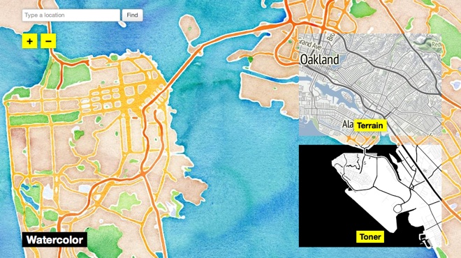
Nachdem u.a. Foursquare, mapquest und iPhoto für iOS von Google Maps zu OpenStreetMap gewechselt sind, wird letzteres immer populärer. Ein Vorteil freier Kartendaten ist auch, dass man sie leicht umgestalten kann (Beispiel: Taxonomy). Stamen Design hat grad drei schicke Kartendesigns unter CC-Lizenz veröffentlicht.
Kommentare
Wenn nur alle ihre Edits nicht bei Google Maps, sondern bei OSM eintragen würden…
http://www.google.com/mapmaker/pulse
Andererseits muss man aber auch sagen, dass Google Maps deutlich benutzerfreundlicher ist, wenn man z.B. schnell eine Adresse herausfinden, die Routhe dahin bestimmen oder eben Änderungen eintragen will. OSM hat dafür aber die ganzen Fahrradwege. Und Bing hat diese ganzen coolen features mit 3D-Ansicht und bald vielleicht auch Videoübertragung an der richtigen Stelle im Panorama-Bild (gabs mal nen TED-Vortrag dazu).
Pretty good, though I think it's one of those case where using an array is wanrarted (granted we don't really care about performance but eval still needs a lot of random access ). Also I was not really convinced by the way you did your layout, so I wrote more general functions, and it turned out shorter too :gridToPic :: Board -> PicturegridToPic = displayGrid (15,15) . (map . map) toPic . toList2D where toPic True = color (dark red) $ rectangleSolid 12 12 toPic False = color orange $ rectangleSolid 12 12type Dir = (Float, Float)type Size = FloatdisplayGrid :: (Size,Size) -> [[Picture]] -> PicturedisplayGrid (xSize,ySize) = displayRow dirY ySize . map (displayRow dirX xSize)displayRow :: Dir -> Size -> [Picture] -> PicturedisplayRow dir size ps = pictures . zipWith (uncurry translate) moves $ ps where moves = iterate (^+^ step) start start = (-(fromIntegral $ length ps – 1) * (1/2)) .*^ step step = size .*^ dirdirX = (1,0)dirY = (0,-1)Anyway, it's pretty cool what you can do with Gloss (though I prefer diagrams if we just want a still image, it's more general).
wot